|
|
|
ˇˇ
A model to evaluate the environmental impacts of transport in the dublin urban area
1,2
A.W. Reynolds & 1 B.M. Broderick,return
ˇˇ
1
Air Quality Research Group,2 Dept. of Mechanical Engineering,Dept. of Civil Engineering, National University of Ireland, Galway,
Trinity College, Dublin Galway
ˇˇ
ˇˇ
ABSTRACT
ˇˇ
This paper describes the development of an integrated mobility/emissions model (IMEM). The detail and structure of the model allow more reliable calculations of mobile source emissions based on appropriate spatial- and time-resolved consideration of vehicle activity within a traffic network. The model is designed to incorporate the finer spatial-resolved vehicle activity data (i.e. street by street) and time-resolved modal emissions data, (i.e. data that are directly related to the vehicle operating modes, such as steady-state cruising, queuing, accelerating and decelerating). As a test case, the model is being applied to Dublin City. The emissions produced on a given link or road can be displayed on a geographic information system (GIS) of the city and can be identified on the basis of transportation planning data. Any subsequent changes in emission levels due to alterations in the road network, can then be automatically assessed by creating different input data sets for the various scenarios to be evaluated.
ˇˇ
ˇˇ
INTRODUCTION
ˇˇ
The atmosphere of the worldˇŻs cities is increasingly affected by air pollution. Hence, deteriorating air quality is fast becoming one of the most pressing and unrelenting environmental problems of our times. Poor air quality in large metropolitan areas is not a new concern, but the nature and type of air pollution has changed over the last number of years. In the past, pollutants were emitted primarily from the industrial and domestic sectors. Now, emissions from road traffic are the principal source of air pollutants in all large conurbations throughout the world. These emissions can have substantial impacts on the local environment (e.g. degradation of buildings and health effects). In order to assess these impacts, the quantity of emissions produced must first be determined. There are many methods of calculating emissions from traffic; one study alone identified 30 calculation methods in use in Europe [Negrenti, 1995]. Many of these methods estimate emissions using traffic data from mobility models. However, mobility and emission models tend to be developed separately and this leads to conceptual and data difficulties when their results are combined. To avoid these problems, an integrated mobility/emissions model has been developed.
ˇˇ
The layout of the paper is as follows. First, the mobility component of the IMEM is first described in detail. Sample results pertaining to the mobility module are then given. The interface between the emissions and mobility components are discussed. A summary of the results from the IMEM is shown. Due to the fact that the emissions module is heavily dependent on motor vehicle statistics, a sensitivity analysis is carried out on the primary input parameters. Finally, the scope for future work in the project is outlined.
ˇˇ
ˇˇ
ˇˇ
Mobility ModULE
ˇˇ
The mobility model used in this study comprises of SATURN (Simulation and Assignment of Traffic in Urban Road Networks) [Van Vliet, 1995] and SATCHMO (SATURN Travel CHoice MOdel) [Hall, 1996]. The mobility model provides a detailed representation of the greater Dublin transportation system including junctions (e.g. priority, signal and roundabout) for both average weekday morning peak and afternoon inter-peak hours. The model distinguishes between three vehicle types, namely light duty vehicles (LDVs), heavy goods vehicles (HDVs) and buses. The period from 8 AM to 9 AM is assumed to be representative of the peak hour while that from 2 PM to 3 PM is assumed to be representative of the inter-peak hour [Steer Davies Gleave, 1993]. For modelling purposes the city is divided into a number of zones.
ˇˇ
The mobility model is divided into four primary modules: trip generation and attraction, trip distribution, modal split, and assignment. The units in which these modules operate are trips. A trip can be defined as a one-way movement from an origin to a destination, for each of which the traveller has a purpose.
ˇˇ
The trip generation module predicts the number of trips generated in a zone as a function of socio-economic, socio-demographic, and behavioural characteristics of that zone. These characteristics include total population, working population, school aged population, employment places, school places, total households and average salary. The generation model can be described as a zonally based local model, where ˇ®localˇŻ implies that zones are addressed individually rather than being subject to uniform pre-determined growth rates. The trip generation predictions are grouped according to trip purpose with the minimum distinction being work, school, business and other (e.g. social and recreational). Non-home based trips are modelled separately.
ˇˇ
The trip attraction module predicts the number of trips attracted to that zone. There are separate attraction models for separate travel purposes. For example, there is an attraction model for home to work trips as a function of zonal employment and an attraction model for shopping trips as a function of retail floor-space. The attraction model does not include transportation variables.
ˇˇ
In the trip distribution module, the forecasted number of trips generated by each origin zone attracted to each destination zone is modelled.
ˇˇ
The modal split module determines the mode of transport that is used. The functional form employed is the ˇ®availabilityˇŻ or ˇ®non-availabilityˇŻ of a car to distinct categories of individuals or market-segments. The categories with a car-available at the time of their trip have a choice of using the car or public transport (i.e. bus or rail). On the other hand, the categories with no-car-available at the time of trip are limited to public transport. The choice methodology is arranged in a hierarchical configuration. The actual modal split is determined by employing ˇ®logitˇŻ formulation and the application of generalised ˇ®costˇŻ parameters. These cost parameters are calculated from research methods (e.g. stated preference surveys) and the relative costs of private and public transport. Private transport costs includes such variables as vehicle operating cost and parking charges, while public transport costs include fares, in-vehicle time, transfer time, walk time and waiting time.
ˇˇ
The assignment module uses two sub-models to assign trips between all zone pairs to links, based on the minimum time (or cost, or combinations of time and cost) path between zones and also on capacity constraints. The first sub-model employs cyclic flow profiles to represent the movement of platoons of motor vehicles over a road network. This sub-model takes account of the interaction of different flows at roundabouts, signal controlled and priority junctions. It requires data concerning the flow on each link in the network to determine queues, capacities and time delays. A separate sub-model employs a ˇ®trip-matrixˇŻ to determine these flows. The module also assigns passengers to public transport networks. Mode choice and assignment in congested urban networks are co-dependant.
ˇˇ
There are two generic inputs for the mobility model, namely the ˇ®trip-matrixˇŻ and the ˇ®networkˇŻ, which may be regarded as ˇ®demandˇŻ and ˇ®supplyˇŻ inputs. The trip-matrix specifies the number of trips from zone to zone and the ˇ®networkˇŻ specifies the geographical location and topography of the carriageways upon which the trips take place. The primary source of raw data for the trips-matrices is a comprehensive set of kerbside surveys and public transport origin/destination interviews (i.e. on-board and bus-stop/rail-station interviews). Obviously, it is next to impossible to generate trip-matrices to cover all of Dublin from the above methods. Therefore, traffic count surveys and air passenger traffic were used to assist in the derivation of ˇ®most-likelyˇŻ trip-matrices. The latter trip-matrices can be used to ensure that the assigned flows match the observed flows within certain pre-defined limits. Individual matrix cells represent the number of trips from one zone to another. Total trips to and from a specific zone for a given period of time are determined from trip matrix column and row totals. Separate matrices are created for two time periods (peak and inter-peak) and four modes of transport (car, HGV, bus and rail).
ˇˇ
The physical network comprises all motorways, main roads, secondary roads, and the more commonly used minor streets. The junctions are represented by a series of uniquely numbered four-digit nodes while the segments of carriageways are represented by links. The links are defined in terms of the nodes at either end. Traffic enters a link at one node and exits at another node. A ˇ®turnˇŻ is represented by a sequence of three node numbers: start, end and next. The network in Dublin is divided into two distinct parts ¨C ˇ®innerˇŻ and ˇ®outerˇŻ. The inner network has a relatively high number of junctions in comparison to carriageways while the outer network mainly contains road data.
ˇˇ
Both the trip-matrices and road network are employed in a ˇ®route choiceˇŻ model which allocates trips to ˇ®routesˇŻ throughout the network, as a result of which total volume flows along links may be summed and the corresponding network ˇ®costsˇŻ calculated.
ˇˇ
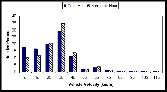
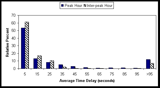
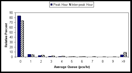
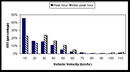
Figures 1 to 3 shows the relative distribution of peak and inter-peak hour velocity (km/hr), time delay (seconds), and average queue (pcu) in the greater Dublin area. Figure 4 displays the percentage of peak and inter-peak hour kilometres travelled relative to velocity for all links in the study area. The variation of vehicle kilometres travelled (VKT) for various velocities are characterised by the majority of kilometres travelled to have occurred at velocities less than 50 km/hr. A greater amount of time is required to travel trips at lower velocities. Therefore, a large number of vehicle hours are necessary to travel the number of vehicle kilometres shown in Figure 4 for velocities less than 50 km/hr. Few kilometres are travelled for velocities between 70 and 90 km/hr. However, an astonishingly large number of VKT occur at velocities greater than 90 km/hr. This is due to the large amount of traffic travelling on the ˇ®C-RingˇŻ and other motorways. Figure 5 displays the large number of hours spent travelling at low velocities. For example, during peak hour, forty-five percent of vehicle hours travelled (VHT) are at velocities of 10 km/hr or less. Figures 4 and 5 represent the possible inefficiency within the road network in the greater Dublin area. The transportation time of the vehicles travelling under congestion conditions has numerous costs. These include costs extra time spent travelling, additional vehicle operating costs, and the additional pollutants emitted at low velocities.
ˇˇ
ˇˇ
Mobility/Emissions Model Interface
ˇˇ
The mobility model provides static and dynamic data for each road link in the greater Dublin area. Static data is passed only once to the emissions model, while dynamic data is updated depending on the simulation (peak or inter-peak). Shared parameters between the mobility and emissions models are shown in Table 1.
ˇˇ
ˇˇ
Parameter |
Classification |
Type |
link length |
topography |
static |
link grade |
topography |
static |
vehicle type |
fleet characteristic |
dynamic |
traffic volume |
travel activity |
dynamic |
average link velocity |
travel activity |
dynamic |
average queue length |
travel activity |
dynamic |
average link time-delay |
travel activity |
dynamic |
average turn time-delay |
travel activity |
dynamic |
ˇˇ
ˇˇ
Table 1: Shared Parameters between Mobility/Emissions models
ˇˇ
Clearly, it is difficult to calculate pollutant emissions for traffic from mobility model data alone. A further breakdown of the fleet characteristics and activity data for each road link is required and is estimated from statistical data for all of Dublin. The statistical characteristic data includes engine technology and capacity, type of fuel used (petrol or diesel) and the age profile of the fleet, while the activity data includes average trip length (km), number of cold- and hot-starts and average acceleration and deceleration (km/hr-sec). This statistical data is assumed to be constant both through time of day and day of week. Some of the data used in this module were derived from traffic surveys, video detection systems and SCATS induction loop data [SCATS, 1998]. However, several sources of existing data were also employed, including the Automobile Association of Ireland, Central Statistics Office (CSO), Dublin Bus, Dublin Corporation, Dublin Transport Office (DTO), Department of Environment and local Government, Society of the Irish Motor Industry and the National Roads Authority (NRA).
ˇˇ
Emissions Model Classification |
Mobility Model Classification |
|||
LDV |
HDV |
Buses |
||
| Cars (petrol) | <1.4l | 36.30% |
ˇˇ | ˇˇ |
| Without catalysts | 1.4l - 2.0l | 22.35% |
ˇˇ | ˇˇ |
| ˇˇ | >2.0l | 1.39% |
ˇˇ | ˇˇ |
| Cars (petrol) | <1.4l | 11.46% |
ˇˇ | ˇˇ |
| With catalysts | 1.4l - 2.0l | 7.06% |
ˇˇ | ˇˇ |
| ˇˇ | >2.0l | 0.44% |
ˇˇ | ˇˇ |
| Cars (diesel) | <1.4l | 7.82% |
ˇˇ | ˇˇ |
| ˇˇ | 1.4l - 2.0l | 4.81% |
ˇˇ | ˇˇ |
| ˇˇ | >2.0l | 0.30% |
ˇˇ | ˇˇ |
| LGV (petrol) | <3.5 tonne | 0.46% |
ˇˇ | ˇˇ |
| LGV (diesel) | <3.5 tonne | 7.60% |
ˇˇ | ˇˇ |
| HGV (diesel) | 3.5t - 7.5t | ˇˇ | 51.17% |
ˇˇ |
| ˇˇ | 7.7t ¨C 17t | ˇˇ | 45.97% |
ˇˇ |
| ˇˇ | 17t ¨C 38t | ˇˇ | 2.86% |
ˇˇ |
| Buses | <16 seats | ˇˇ | ˇˇ | 0.54% |
| ˇˇ | 17 ¨C 35 seats | ˇˇ | ˇˇ | 23.03% |
| ˇˇ | >36 seats | ˇˇ | ˇˇ | 74.59% |
| Coaches | >36 seats | ˇˇ | ˇˇ | 1.84% |
ˇˇ
ˇˇ
Table 2: Vehicle Type Mapping between Emissions and Mobility Model
In total, eighteen vehicle categories for each year are employed in the emissions model. However, as the mobility model only predicts traffic volume for three categories, a vehicle type mapping is required between the emissions model and the mobility model. This mapping is shown in Table 2. It should be noted that this mapping changes with availability of emission factors.
ˇˇ
ˇˇ
Emissions ModULE
Motor vehicle emission calculations is generally determined through the sum of running, start-up and fuel evaporative emissions:
E = Erunning + Estart-up + Eevaporative
The combustion process produces exhaust emissions while the engine is running. These vary with engine conditions (e.g. enrichment, lean-burn) and mode of operation (idle, creep, acceleration, deceleration and cruise). When an engine is started, emissions are substantially higher than when the engine is in a hot-stabilised mode because it takes time for the engine to reach its normal operating temperature. If the engine is started for the first time in the day (cold start-up), it will be cold but, unless the vehicle has been shut-off for several hours, subsequent starts will not be truly cold (hot start-up). Cold start-up emissions are higher than hot start-up ones. Also catalytic converters do not become effective until they have reached their normal operating temperature.
Pollutants also escape into the atmosphere through fuel evaporation. There are four primary sources of evaporative emissions, namely, diurnal losses, running losses, hot-soak losses and refuelling losses. Diurnal losses occur because fuel evaporation increases as the temperature rises during the day heating the fuel tank and venting fuel vapors. Running losses occur because fuel evaporates from the fuel system when the engine is started while hot-soak losses occur when fuel continues to evaporate from the fuel system after the engine has been shut-down. Fuel vapor that is present in the tank is also displaced during refuelling.
The emissions model distinguishes for each vehicle category different sub-categories defined on the basis of successive EU emission legislation, the technology concept employed, the vehicle-operating mode and the fuel used.
The model can predict key motor vehicle pollutants such as sulphur dioxide (SO2), oxides of nitrogen (NOx), carbon monoxide (CO), carbon dioxide (CO2), non-methane volatile organic compounds (NMVOC) and total suspended particulate matter (TSP). It also can predict less frequently-considered pollutants such as benzene (C6H6), 1,3-butadiene (C4H6), particulate matter less than 10-mm aerodynamic diameter (PM10), methane (CH4) and black smoke.
ˇˇ
Carriageways with more than one lane are modelled as separate links running adjacent to each other. Each lane is divided into a number of segments reflecting the areas in which vehicles are more likely to be in cruise or queuing mode; all vehicles that are not queuing in a lane are assumed to be cruising. For these vehicles, an average velocity is assumed over the street length and an entirely velocity-dependent emission-rate is employed. For queuing vehicles, the mean queuing period at each location is used to calculate stationary emissions.
ˇˇ
ˇˇ
Emissions Factors Database
ˇˇ
The emissions factors database (EFD) contains all the emission factors required by the model. It has been generated using data from over 100 published reports on conventional and alternative fuels. Since no emission factors are available specifically for Ireland, the CEF used in this study are derived from three primary external sources, namely, emission factors developed for the UK, emission factors produced under EU initiatives, such as CORINAIR [Aklvik et. al, 1997], MODEM [Jost et. al, 1992], MEET/COST 319 [Joumard, 1998] and the European Environment Agency's Atmospheric Emissions Inventory Guidebook [McInnes, 1996], and the US EPA manual on the Compilation of Air Pollution Emission Factors (AP-42) [US EPA, 1997]. Since the methodology developed in the emissions model is generic, future improved emission factors can be readily incorporated into the database.
ˇˇ
ˇˇ
SAMPLE RESULTS
ˇˇ
The temporal resolution of output from the module can be annual, seasonal, daily, or hourly. Since motor vehicle emissions are strongly sensitive to the ambient temperature, the most accurate approach is an hour-by-hour estimation. However, the mobility model currently being used does not temporally resolve and apportion estimates of traffic data and fleet characteristics into hour-by-hour (or daily) values. Instead, it simulates typical peak and inter-peak hours. Tables 3 and 4 summarise the results for greater Dublin area IMEM. Table 3 shows total pollutant emissions for typical peak and inter-peak hours.
ˇˇ
ˇˇ
Pollutant (kg) |
Peak hour |
Inter-peak hour |
| SO2 | 51.64 |
28.65 |
| CO2 | 138,230.05 |
74,939.02 |
| CO | 11,049.08 |
5,431.46 |
| NOX | 1,413.42 |
799.25 |
| CH4 | 31.30 |
15.85 |
| NMVOC | 1,492.77 |
746.62 |
| 1,3-Butadiene | 14.01 |
6.99 |
| Benzene | 43.72 |
21.27 |
| PM10 | 88.42 |
56.10 |
| Smoke | 253.16 |
159.70 |
| TSP | 116.73 |
72.52 |
ˇˇ
ˇˇ
Table 3: Total Pollutant Emissions from Road Traffic in Dublin
Table 4 shows the relative contribution by each of the primary vehicles to total road traffic emissions of each pollutant. The percentage VKT for each type of vehicle is also shown for reference purposes. For example, petrol cars contribute to 67.92% of the total VKT in the greater Dublin area, emit 93.64% of the CO, but only emit 11.19% of the TSP.
ˇˇ
Percentage Breakdown |
Cars (petrol) |
Cars (diesel) |
LGV (petrol) |
LGV (diesel) |
HGV |
Buses |
| VKT | 68.33% |
11.18% |
0.63% |
10.39% |
5.61% |
3.85% |
| SO2 | 46.76% |
8.72% |
0.91% |
5.12% |
21.53% |
16.96% |
| CO2 | 53.17% |
7.52% |
0.33% |
6.28% |
14.96% |
17.74% |
| CO | 93.42% |
0.46% |
0.49% |
0.39% |
1.45% |
3.79% |
| NOX | 49.93% |
2.55% |
0.34% |
4.00% |
20.10% |
23.09% |
| CH4 | 83.46% |
1.34% |
0.78% |
0.79% |
8.09% |
5.54% |
| NMVOC | 86.70% |
0.52% |
0.45% |
1.57% |
2.37% |
8.39% |
| 1,3-Butadiene | 85.03% |
2.91% |
0.65% |
2.28% |
5.17% |
3.96% |
| Benzene | 96.32% |
0.50% |
0.98% |
0.46% |
1.02% |
0.71% |
| PM10 | 12.18% |
9.47% |
0.11% |
9.16% |
37.57% |
31.50% |
| Smoke | 7.39% |
15.41% |
0.14% |
9.05% |
38.05% |
29.97% |
| TSP | 16.18% |
10.04% |
0.12% |
9.07% |
34.50% |
30.09% |
ˇˇ
ˇˇ
Table 4: Contribution of Different Categories of Vehicles to Total Emissions
ˇˇ
In order that the emissions model may be calibrated and validated, the predicted emissions at a number of heavy-trafficked junctions in Dublin City centre were employed in a dispersion model along with local meteorological conditions and site geometry [Reynolds & Broderick, 1998]. The resultant pollutant concentrations were compared to ambient conditions measured with state-of-the-art monitoring equipment [Marnane et. al, 1998]. Preliminary experiments indicate that predicted concentrations are in good agreement with measured ones. It is envisaged that the model will be further validated at other sites throughout Dublin [Reynolds & Broderick, 1999].
ˇˇ
ˇˇ
SENSITIVITY ANALYSIS
ˇˇ
Sensitivity analysis is a means of evaluating the comparable significance of the output from IMEM to its variable input parameters. One of the most common techniques used in sensitivity analysis is the ˇ®non-interactiveˇŻ procedure [Lane & Nichols, 1997]. Calculations are performed initially by employing the best-estimated values (nominal parameter values) of the input parameters. All input parameters are then fixed at their nominal values, except one, which is varied in a sequential and independent manner about its nominal value. It is important that the range of values used in this analysis is feasible and realistic. The calculations are then repeated and the resultant set of output values displays how the IMEM operates with respect to key input parameters. It also demonstrates the relative importance of changes in each variable input parameter in determining changes in the resultant output values.
ˇˇ
The methodology is generic, straightforward and relatively easy to perform. The results are amiable to graphical and tabular representation as they are numerical and do not involve complex formulae. Most importantly, the methodology is independent of the model structure and is therefore generally applicable to all models. The main disadvantage of the methodology is that input parameters are varied individually and therefore interactions between them are not resolved. The sensitivity of the IMEM to variations in the input parameters is very dependent on the initial estimate of the nominal values. Also, the methodology is fundamentally empirical in nature and therefore does not draw on what is known of the IMEM structure.
ˇˇ
By varying seven input parameters that depend heavily on statistical data for all of Dublin, a non-interactive sensitivity analysis for the IMEM was performed. These parameters included cold mileage percentage (CMP), number of diesel cars, number of petrol LGVs, ratio of LGVs to cars, number of cars with a catalytic converter, average trip length and average ambient temperature. The nominal values of these are 34.95%, 14.1%, 5.7%, 8.06%, 24%, 9.46 km and 10oC respectively.
ˇˇ
Some of the results are surprising, but are a consequence of the emission factors used rather than the IMEM (for example, only ˇ®coldˇŻ emission factors were available for key pollutants). All the sensitivity analysis carried out displayed a ˇ®reductionˇŻ effect, whereby changes in output are smaller than the corresponding changes in the input parameter value. Some pollutants are more sensitive to a particular input parameter than others. As an example, NMVOC is relatively sensitive to any change in trip length, while CO2 is not as sensitive.
ˇˇ
The magnitude of the sensitivity to the database for the varied input parameters can be expressed as the covariance (the average of the products of deviation for each data point pair in two data sets). In other words, covariance is a measure of the relationship between two sets of data. The complete results of the parameter sensitivity analysis for the input parameters are shown in Table 5. Small covariance values indicate larger changes in varied input parameter values than the corresponding output values and vice-versa. A positive covariance value means a positive correlation and vice-versa. Table 5 allows varied input parameters of different magnitudes to be compared and evaluated. For example, an increase in the percentage of cars with a catalytic converter results in a slight increase in CO2 and a decrease in CO, NMVOC, and NOX.
ˇˇ
Covariance Matrix |
CMP |
% diesel cars |
% petrol LGVs |
% LGVs to cars |
% cars with catalyst |
Average Trip Length |
Average Ambient Temp. |
| SO2 | n/a |
0.0044 |
0.0024 |
0.0048 |
n/a |
n/a |
n/a |
| CO2 | 0.0182 |
-0.0048 |
-0.0002 |
0.0049 |
0.0047 |
-0.0104 |
-0.0032 |
| CO | 0.1125 |
-0.0614 |
0.0018 |
-0.0306 |
-0.0780 |
-0.0644 |
-0.0196 |
| NOX | 0.0055 |
-0.0222 |
0.0004 |
-0.0011 |
-0.0446 |
-0.0031 |
-0.0010 |
| CH4 | n/a |
-0.0509 |
0.0030 |
-0.0242 |
n/a |
n/a |
n/a |
| NMVOC | 0.1255 |
-0.0563 |
0.0014 |
-0.0235 |
-0.0891 |
-0.0719 |
-0.0219 |
| 1,3-Butadiene | n/a |
-0.0456 |
0.0021 |
-0.0198 |
n/a |
n/a |
n/a |
| Benzene | n/a |
-0.0635 |
0.0040 |
-0.0293 |
n/a |
n/a |
n/a |
| PM10 | n/a |
0.0300 |
-0.0018 |
0.0296 |
n/a |
n/a |
n/a |
| Smoke | n/a |
0.0569 |
-0.0016 |
0.0288 |
n/a |
n/a |
n/a |
| TSP | 0.0115 |
0.0367 |
-0.0019 |
0.0312 |
-0.0103 |
-0.0066 |
-0.0020 |
ˇˇ
ˇˇ
Table 5: Covariance of Varied Parameters and Resultant Pollutants
ˇˇ
ˇˇ
ˇˇ
CONCLUSIONS AND FUTURE WORK
The model will allow decision-makers to evaluate the environmental impacts of new infrastructures (e.g. C-ring motorway, Dublin Port tunnel), transport policies (e.g. quality bus corridors, suburban light rail transit, park-and-ride facilities), traffic management schemes (e.g. traffic calming, introduction of one-way streets) and abatement strategies (e.g. use of alternative fuels, scrappage schemes for older vehicles) in Dublin. It will also be a useful tool in determining if areas are likely to exceed standards or attain air quality objectives as set out under EU Directives. The model will be made available to the general public through the Dublin Transport Office who will also maintain it.
ˇˇ
ˇˇ
Acknowledgements
ˇˇ
The authors would like to accredit the support of Dublin Transport Office (DTO) and ESB International, who both partially funded this study. Thanks are due to the organisations that supplied statistical data, and WS Atkins Planning for the use of SATURN and SATCHMO models.
ˇˇ
ˇˇ
References
ˇˇ
Aklvik, P., Eggleston S., Gaudioso, D., Gorißen, N., Hassel, D., Hickman, A.J., Joumard, R., Ntziachristos, L., Rijkeboer, R.C., Samaras, Z., & Zierock, K.H., (1997), COPERT II ¨C Computer Program to Calculate Emissions from Road Transport, CORINAIR, European Topic Centre on Air Emission, European Environment Agency, Copenhagen.
Hall, M., (1996), SATCHMO User Manual, WS Atkins Planning Consultants Ltd.
Jost, P., Hassel, D., Weber, F., & Sonnborn, K., (1992) Emission and fuel consumption modelling based on continuous measurements, MODEM, modelling of emissions and consumption in urban areas, Deliverable No. 7, DRIVE Project Report.
Joumard R. (1998) Methods of estimation of atmospheric emissions from transport: European scientist network and scientific state-of-the art, MEET ¨C Methodologies for the Estimation of Emissions from Transport, Final Report.
Lane, L.J. & Nichols, H., (1997) Complexity, Uncertainty, and Systematic Error in Hydrologic Models, U.S. Department of Agriculture.
Marnane, I., Keating, D., Broderick, B. & Misstear, B, (1998), On-line monitoring of air pollution concentrations due to vehicular emissions in Dublin, Proceedings of the 30th UTSG conference, Dublin.
McInnes, G., (1996), Atmospheric Emissions Inventory Guidebook, produced jointly by EMEP/CORINAIR, prepared by the EMEP Task Force on Emission Inventories, European Environment Agency, Copenhagen.
Negrenti, E. (1995) Bottom-up traffic emission models, COST 319 Report. European Commission, Directorate General for Transport, Brussels, 115-126.
Reynolds, A.W. & Broderick, B.M., (1998), On Road Motor Vehicle Emissions Inventory Model, Urban Transport and the Environment for the 21st Century, Computational Mechanics Publications, Ashurst Lodge, Southampton, UK, ISBN 1853125970.
Reynolds, A.W. & Broderick, B.M, (1999), Air Pollution Monitoring and Modelling in Dublin, Proceedings of 9th Environmental Researchers Colloquium, Johnstown Castle, Wexford.
SCATS (1998) Dublin Area Traffic Control System, Office of the Director of Traffic, Dublin Corporation, Civic Offices, Fishamble Street, Dublin 8.
Steer Davies Gleave, (1993) Dublin Transportation Initiative, Published by the Irish Government Stationery Office, Dublin.
US EPA, (1998), Compilation of Air Pollutant Emission Factors (AP-42), Air and Radiation, Office of Mobile Sources, U.S. Environmental Protection Agency.
Van Vliet, D., (1995) SATURN 9.2 User Manual, Institute for Transport Studies, University of Leeds.
APPENDIX
ˇˇ
Figure 1: Relative Distribution of Link Peak and Inter-peak Hour Velocities
ˇˇ
Figure 2: Relative Distribution of Link Peak and Inter-peak Hour Time Delays
ˇˇ
Figure 3: Relative Distribution of Link Peak and Inter-peak Hour Average Queues
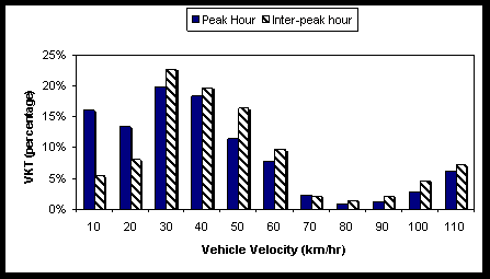
Figure 4: Vehicle Kilometres Travelled (VKT) by Average Velocity
ˇˇ
Figure 5: Vehicle Hours Travelled (VHT) by Average Velocity