|
|
|
How will route guidance and navigation systems affect cognitive maps?/ Jackson, P.G.
(1996a)
Proceedings of PTRC, the 23rd European Transport Forum, Warwick University, 11th-15th
September 1995.
HOW WILL ROUTE GUIDANCE AND NAVIGATION SYSTEMS AFFECT COGNITIVE MAPS?
Paul G Jackson
Centre for Transport Studies
Imperial College
London
.Sw7 2BU
1 INTRODUCTION
In-vehicle route guidance and information (IVRGI) systems aim to reduce traffic congestion and its associated environmental, social and financial costs by making drivers more aware of the various options available to them in making a journey. The benefits predicted to arise from widespread use of such systems depend in part upon their presumed ability to increase and enhance individuals' 'cognitive maps' of their environments: "Cognitive maps influence travel behavior...for example, the propensity to divert in the face of congestion is related to the number of routes known to a person. The potential for expanding and enriching cognitive maps through ATIS may be substantial... " Schofer et al ., (1993) p .108 This paper considers this issue and questions what effect route guidance and navigation systems will have upon an individual's ability to acquire and subsequently use cognitive maps? Due to space limitations the paper does not describe cognitive mapping research and theory in any detail, those wishing for more information are directed to reviews such as Evans (1980), Golledge (1987). and Kitchin (1994).
2 PREVIOUS RESEARCH AND THEORETICAL BACKGROUND
Human factors research has considered ease of use, safety and efficiency aspects of information provision via IVRGI systems. Research has also compared the ability of drivers to navigate using various modes of presentation: spoken instructions; visual display in the form of a route map or computer based map; or a textual list of directions (e.g. Dingus and Hulse, 1993; Srinivasan et al., 1994). This research suggests that the amount of information provided to drivers in-transit should be limited to what is absolutely necessary due to the attention and information processing demands of the driving task (Streeter et al., 1985; Dingus and Hulse, 1993). The visual sense is clearly of central importance to driving (Wierda and Aasman, 1992) indeed, research suggests that 30% of all accidents are due to visual perception errors (Staughton and Storie, 1977). From a safety perspective, therefore, it is likely that spoken directions will be the main source of information for drivers using IVRGI systems, with a computerised map available for reference. Further, research suggests that drivers actually prefer auditorily presented route guidance messages to maps (Streeter et al., 1985; Burnett and Joyner, 1994) In keeping with this research, subjects in the present study will be provided with the necessary information required to perform a way finding task. This will include details of the next turn, distance to this turn, what street to turn on and which direction to turn (Streeter et al., 1985). It should be noted that the instructions given are prescriptive in content, as opposed to descriptive. It is likely that there are differences in the way that subjects deal with the two forms of information. The present study concentrates upon prescriptive information, with subsequent research planned to consider possible differences between the two forms.
2.1 Effects of additional information upon cognitive mapping.
All problem solving relies on our ability to conceptualise a problem and in so doing construct a cognitive representation of it. Solving the problem requires the ability to operate on this representation to produce overt behaviour (Golledge et al., 1985). It is assumed that additional route guidance information will enhance the problem representation and thus enhance the process of cognitive map acquisition. Under normal circumstances, the act of wayfinding assists in this acquisition process, the active search for salient landmarks and other cues to navigation strengthens the representation formed. Increased experience within an environment would also normally result in stronger cognitive representations of that environment leading to reduced uncertainty and driver stress, while increasing driver confidence. Route guidance information, in the form of specific directions, may reduce uncertainty on an isolated trip, but might it also interfere with the process of forming a mental representation of the unfamiliar area? Will increased experience within the environment be different when accompanied by additional information? Will additional information enhance cognitive map acquisition or interfere with it?
2.2 The study area
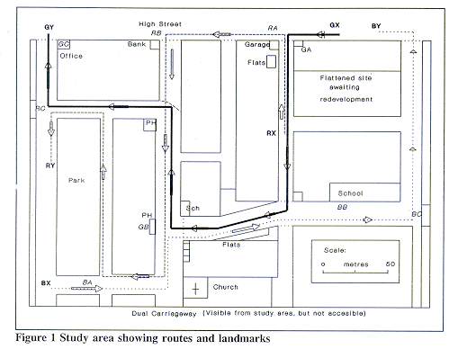
In a recent review of previous research (Jackson, 1995) it was noted that photographic slides have been The most common method used to provide subjects with knowledge of an unfamiliar environment. In addition, past research has used two partially overlapping routes to provide configurational, or survey knowledge of an area. Objections could be raised, however, as to the veridicality of the survey knowledge acquired by subjects witnessing two routes, particularly two simple overlapping routes. These issues were previously discussed (Jackson, 1995) with the conclusion that videotape would provide the more realistic, dynamic environment required for this study. The present study thus uses video footage of three interconnecting routes of moderate length, each with at least 4 turns. Although each route on its own gives only partial information, the spatial knowledge acquired from viewing all three routes, if combined into a survey representation of the area, should be quite complete. These routes are marked in Figure 1 as RX-RY (the red route), BX-BY (the blue route) and GX-GY (the green route). The study area was selected following a series of pilot studies (see Jackson 1994) and was filmed using a Sony Super 8 camera fitted with a wide angle lens, giving a viewing angle of approximately 55 degrees. The film was shot between 06.45 and 08.15 on a Sunday morning in late September, when there was minimal traffic in the area. The study area is bounded in the south by a major dual carriageway (inaccessible from the study area) and in the north by a busy high street. The site was selected because of the varied land uses evident in a small area. The study area contained distinct areas of residential, commercial, industrial, educational and recreational land use which helped to distinguish each of the three routes.
2.3 Simulating the wayfinding process
Under normal circumstances wayfinding is an active, information seeking process, characterised by motivation and purposeful action. A subject simply viewing a film of a journey does not have this motivation. On its own the video merely provides subjects with information about three routes through an area, it does not specifically include a search element. However, the study uses three devices designed to add purpose to the task. These are Pre-trip instructions; Simplified orientating map; and Instruction listing. The pre-trip instructions direct subjects to obtain as much information as possible about the routes, the landmarks on those routes and the way the 3 routes link together. Prior to viewing the first video, subjects are instructed to attend to landmarks and other cues on each route which will help them perform the various tasks later. In this way they are directed to attend to visual information in much the same way as a wayfinding exercise. Before viewing each film subjects are shown a simplified 'map', showing a 7"x 5" rectangle containing two points, one representing the subjects' starting position and the other representing their destination. The maps, although to scale and in the correct orientation, do not show the routes, or any spatial elements such as landmarks or buildings. Simply showing subjects each film would fail to accurately simulate wayfinding, as in reality one would have at least some idea of present location and intended destination. By giving subjects these simplified maps they can better understand the reasons for the route taking particular turns, however, the information given is not detailed enough to give any additional information about the study area or the route to he taken
2.4 Simulating the provision of information
Participants all see the same films but are assigned to one of four experimental conditions which differ in the information heard: Group 1: no additional information; Group 2: hear spoken route guidance instructions (Route guidance group). Group 3: hear a radio broadcast, recorded during the rush hour (Radio group). Group 4: hear radio interrupted by guidance (Route guidance + radio group). This experimental design allows us to compare the effects of salient and non-salient information upon the cognitive mapping process. Route guidance is considered to be salient information, whereas the radio broadcast is considered non-salient. If all groups' spatial knowledge (measured by performance of various tasks) is significantly inferior to that of group 1 then the mere presence of a secondary information source, regardless of its content, is placing extra demands on processing and is thus affecting the cognitive mapping process. If the performance of subjects in the salient information (route guidance) group is better than that of the video only group then the presence of additional salient information can be seen to have had a positive effect upon the cognitive mapping process. However, if the route guidance group's performance is inferior to that of the other groups then it is likely that the extra processing required to attend to this additional information has had a detrimental effect upon cognitive mapping processes. The presence of the fourth group enables us to consider the use of route guidance information systems in a naturalistic situation whereby route guidance information is set up to override the radio broadcast. It also enables us to test subjects' ability to switch attention processes between incoming salient and non-salient information in addition to processing information provided by the visual sense.
Ensuring subject attention
An individual using a route guidance system in reality responds to the guidance by making the adjustments necessary to produce a required change in direction. In the laboratory situation it would be unrealistic to ask subjects to respond to the guidance instructions in a way comparable with reality, for example by having them turn a mock up steering wheel. Given that we simply want to ensure that subjects attend to the guidance instructions, it was decided that a simple task was appropriate. Thus, for each video, subjects in the guidance condition write down initial letters corresponding to the headings (N, S, E or W) and to the turns (L or R) they hear. This simple device simulates reality in three ways. First, it ensures that subjects attend to the information, second it ensures that they make a response to this information and third, it ensures that their responses occur in the same sequence as would be the case under natural circumstances 3 EXPERIMENTAL DESIGN The sample is divided into 16 groups spread across 4 experimental conditions, differentiated By the level of information received in addition to viewing the video (which is visually the same in all cases). Subjects are assigned to one of these four conditions based upon their age (there are three age groups: 22 and under, 23-54, SS and over), gender and whether or not they drive. The experiment thus has a 4x3x2x2 factorial design. A total of 106 subjects (53 males, 53 females) took part in the experiment and were each paid £5 for their participation. The age range of the subjects was 18 to 86, (mean age = 35.10). Participants were recruited from a large variety of sources, ranging from advertisements in local newspapers, posters around the Imperial College campus, and a mailing of letters to 48 organisations (Retired persons groups, clubs and societies, community centres, women's organisations etc.).
4 METHOD
4.1 Presentation and Testing procedures
Upon arriving at the testing centre participants were given a sheet of instructions to read and were then shown the simplified map for the first route (see section 2.4) The first video was then shown. All subjects saw two versions of each route, one immediately following the other. The first version shows the route with the camera fixed straight ahead (the route film). The second version is filmed with the camera panning left and right to show the various landmarks along the route (the landmark film). Having seen both versions of the route subjects were then given tasks to perform testing their route and landmark knowledge (described below). For ease of exposition the following describes an experiment in which subjects see first the red route, then the blue and finally the green. However, all combinations of the three routes are tested.
4.2 Tasks
Following the methodology of Golledge et al. (1993) the present study uses a battery of tests designed first to help subjects organise the information acquired from the screening of each individual route (sequencing, distancing and single route pointing tasks), and second to test their ability to integrate the information acquired into a configurational representation of the area as a whole (cross route pointing tasks and sketch map). Measuring route and landmark knowledge acquisition: sequencing and distancing tasks After viewing both the route and landmark films for the red route subjects were moved to a different part of the room where they performed the sequencing and distancing tasks. Tables were arranged so that each individuals' work was kept private. Subjects were then given a set of ten randomly shuffled 7" x 5" photographs showing route scenes from the red route. (These photographs were taken at the same time of day with weather and road conditions similar to those in the films. Subjects were instructed to arrange these photographs in the order they would appear along the route (the sequencing task). Then, once satisfied that the pictures were in the correct order they were asked to place them along a Im strip of paper taped to their desk, which represented the length of the route just viewed. The photographs were to be placed at their correct (ratio scaled) distances along the route (the distancing task) and this position indicated with a vertical line on the Im strip. Again, subjects were allowed to rearrange the order of photos until they were satisfied that they were distanced correctly. Measuring configurational knowledge acquisition: pointing tasks Having completed the sequencing and distancing tasks for the red route, subjects completed the pointing task for this route. This uses three photographs of key landmarks along the route, listed below:
| Red Route (RX-RY): | Blue Route (BX-BY): | Green Route (GX-GY): |
| Garage (RA) | Church (BA) | Stationery shop (GA) |
| Bank (RB) | School (BB) | Public House (GB) |
| Tjunction (RC) | Modern office (BC) | Offices (GC) |
These are marked on figure 1.
Participants were given a booklet for carrying out the pointing task. The first page of this booklet asked them to estimate the distance travelled on this route, and to give estimates of the time taken to travel each version of the route. The remainder of the booklet contained 6 pages, on each of which was a large circle with a dot at its centre and, at the top of the page, a direction arrow pointing up. They were then given 3 photographs of landmarks along the route just seen and for each photograph were asked to imagine they were standing at the place where the photograph was taken, looking in the direction shown. They then had to estimate the direction from this landmark to each of the other two landmarks. They indicated this direction by drawing a line from the centre of the circle out in the direction of the second landmark relative to the first. This procedure was repeated with each of the landmarks as the origin. Once this task had been completed subjects were taken back to the presentation area to view the route and landmark films for the next route. The same viewing and testing procedures were repeated for all three routes. Configurational knowledge (also known as 'survey' knowledge) is seen as the highest level of spatial knowledge. It involves the integration of knowledge acquired from separate sources into an overall 'configurational' whole. Once subjects have seen all three videos we test to see whether they have acquired configurational spatial knowledge by asking them to carry out the same pointing task as before but this time estimating directions from a landmark on one route to landmarks on the other two routes: in so doing they are creating new routes which they have not previously encountered. This ability is seen as a fundamental indicator of configurational knowledge. Finally, subjects were asked to draw a sketch map of the study area as a whole. They were provided with a pencil, ruler and paper to do this, and told to take as much time as they needed until they were satisfied with their sketch maps. This concluded the experiments.
5 RESULTS
5.1 Sequencing task
The sequencing tasks provide us with data on the differences between the three routes, as well as helping to identify those subjects whose performance is above average (those who successfully sequenced all three routes). The red route is the longest in distance (800 m) and time (5 mins for the first version, just over 6 mins for the second). It is also the most complex, there being 6 turns on the red route, 4 on the blue and 5 on the green route. Consequently, it is no surprise to find that only 19 subjects (17.9%) were able to place the route photographs for this route into the correct sequence. Of these 19, only one was over 55. By comparison 43 (40.6%) were able to correctly sequence the blue route photographs and 47 (44.3 %) put the green route photographs into the correct sequence. Overall, the results for the routes followed a broadly similar pattern, with drivers outperforming non drivers, males slightly outnumbering females and age being a strong indicator of performance. Male and female non-drivers follow a broadly similar pattern of gradually deteriorating spatial ability across the three age groups. Male and female drivers, on the other hand, seem to respond differently to increased driving experience. Of the correctly sequenced routes, female drivers performed best in the under 22 age group, whereas male drivers performed best in the 22-54 age group. Within environment variables There was little difference between the four information groups with regard to the sequencing task, although slightly more subjects in group 1 were able to correctly sequence one or more routes. Similarly, of the 10 subjects who managed to correctly sequence all three routes, 5 were from the video only group. Order of presentation seemed to have some effect, but no clear pattern was evident and differences between the 6 orders of presentation were not statistically significant.
5.2 Pointing tasks
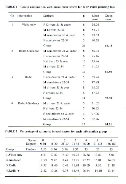
The next measure considered is subject performance of the pointing task. For each direction estimate we calculate the deviation from true direction. This enables us to generate a mean error score for each subject for each route. Group means are also calculated for each of the information conditions and for the various independent variables (age, driving ability and gender). The cross route pointing task enables us to produce an overall mean error score for each subject. A simplistic analysis of the direction estimate results tends to confirm commonly held beliefs: males outperform females, drivers outperform non-drivers, and the youngest outperform other age groups. However, we need to look at the interaction between these various variables. The group means worked out for groups made up by gender and driving ability, for example, show that female drivers are more accurate than male non drivers. and only marginally less accurate than male drivers. Table 1 breaks the sample into its constituent groups and shows how subjects were assigned to the four experimental conditions. The column on the tar right shows the mean error score for each sub-group of subjects for the cross route pointing task.
The mean error scores for the cross-route pointing task provide a useful comparison of subjects' performance across experimental condition and between the various independent variable groups. Most subjects found the pointing tasks quite difficult but subjects in the over 55 age group found the task particularly difficult. For the subject sample considered as a whole, the mean error scores for the cross-route pointing task support previous research suggesting that spatial ability deteriorates with age, and that males are better at spatial ability asks than females. However, the results also suggest that driving enhances spatial ability, with female drivers performing as well as male drivers in most conditions. This is especially evident when one compares the cross route error scores for male and female drivers against male and female non drivers (column 5). The experimental design enables comparisons to be made between like subjects under different information conditions. The performance of male drivers aged 22 to 54 in groups I and 2, for example, shows a surprisingly large difference between the groups' mean error scores (45.76 v 61.73) which, it would appear, is due to the different information condition. A similarly large difference occurs between female drivers in the 22-54 age group watching the videos under the radio condition and those who watch them in the route guidance plus radio condition (Mean error scores of 47.23 v 70.93). To test the significance of these results we performed a regression analysis. All groups were compared against the best performers, (male drivers aged 21 and under) to see whether the groups can be considered to have come from the same population. This analysis showed that the performance of all but four groups can be considered to be significantly different from that of the male drivers in the youngest age group (p<0.0001). Hence all but four groups performed significantly worse than the young male drivers. These groups were:
These results are particularly interesting in that, with the exception of the group of female drivers under 21, in each case a second group of similar subjects saw the videos under one of the route guidance (salient information) conditions. However, the performance of these other groupes was considered to be inferior to that of those who saw the videos i the nonsalient condition. We also carried out an analysis of variance (ANOVA) to test for the significance of interactions between the four independent variables (age, gender, driving ability and information group) When considered individually, all but information group are found to be highly significant (p<0.0005). However, we need to know what interactions exist between these variables. The model is made increasingly complex by keeping these individual effects and simultaneously adding combinations of the four variables to the model. The interactions between gender and driver and between age and group were both found to be significant (p<0.05) To strengthen the model and to give it more cases to work with we collapsed the four mformation groups into two by combining subjects who saw the videos in the no information condition with those who saw them under the radio condition (groups 1 and 3). We do the same with the two salient information conditions so that those in the route guidance condition are grouped with those in the radio plus route guidance condition. Thus we create wa new variable, group_x, which distinguishes between subjects who are exposed to salient information and those who receive non-salient or no information. With this model all four independent variables are significant on their own (age: p < 0.0001; driving ability: p<0.0005; gender: p<0.002; and group: p<0.05). As before we increase the complexity of the model by forming combinations of the four independent variables whilst also keeping them as single variables. This analysis shows that the two-way interaction between gender and driver and the three way interaction between gender, driving ability and information group are all significant (p < 0.05). These results and their implications will be discussed more fully in the discussion section.
5.3 Distance and time estimation
Subjects also estimated the distance travelled and time taken to travel each route. Distance estimates varied considerably across subjects and across information conditions. Indeed the variation between individuals was much greater than that between groups. As such none of the results were significant at the 5% level. Age was the only variable which showed any great variation, with older subjects consistently overestimating the distances for all routes. There were no significant differences between the four information conditions, order of presentation, driving ability or gender. Subjective estimates of travel time show a similarly wide variation between subjects' estimates. However, there were a number of significant results. Age was a significant variable for all three routes (p<0.005), subjects in the 55 and over age group making significantly longer estimates of time than the two younger age groups whose estimates were not statistically different. This was the only significant variable for time estimation on the blue and green routes, but driving ability and the interaction between age, sex and driving ability were both significant for the red route (p<0.05).
5.4 Differences between the three routes
Table 2 summarises the cross route pointing tasks. For simplicity the direction estimates have been grouped into sectors where sector 0 contains estimates within 10 degrees of actual, sector l contains estimates between 11 and 20 degrees from actual etc. up to sector 6 which contains estimates more than 135 degrees from actual. For each condition the table shows the percentage of direction estimates which fall in each sector. The first line ('Random'? shows the percentage of estimates that could be expected to fall into each sector by chance. If we compare the spread of estimates made within each information condition it is clear that subjects seeing the videos in either groups 1 or 3 are generally more accurate than those in groups 2 or 4. If we class estimates falling into sectors 0, 1 or 2 as 'accurate' and those falling into sectors 5 and 6 as 'inaccurate' then 43% of estimates made by subjects in the video only condition and 38% of estimates made by subjects in the radio condition can be classed as accurate. By comparison these figures fall to 31% for the route guidance group and 33% for the radio plus guidance group. In contrast, subjects in the two guidance conditions made more inaccurate estimates than either the video only or radio groups.
6 SUMMARY AND DISCUSSION
This research project started out with 4 primary aims:
6.1 Providing subjects with configurational spatial knowledge using video
The problematic nature of attempting to provide subjects with configurational knowledge of an unfamiliar area via direct experience of that environment has led researchers to consider simulated environments as an alternative. The vast majority of this research has used slides to provide experience of the unfamiliar environment. However, the present study wanted to consider the effects of route guidance information upon subjects' distance and time estimates, which would have been impossible using the conventional slide technique. Consequently, video footage was used. It is difficult to gauge the success of this approach, there being very little previous research with which to make comparisons. It is clear that not all subjects were able to acquire configurational knowledge of the area, yet that would have been the case were we using slides, video, computer simulations or a real environment. Our results show that after only two exposures to each route, many subjects were able to draw a sketch map of the area and were able to estimate directions from landmarks on one route to landmarks on the other two with some degree of accuracy. Like Golledge et al., (1993) we used an unfamiliar environment and tried to provide subjects with configurational knowledge of this area. However, we attempted to provide an external frame of reference through the use of a simplified 'map' showing only the start point, destination and the area in which the journeys would all take place. This device did not give subjects any additional information, but served both to locate the journeys within a wider frame of reference and also gave an element of purpose to the directions taken on each journey. Whilst many of our subjects found the experiment difficult. the results show that the majority had acquired a reasonably accurate mental representation of the area as a whole, despite making mistakes on the various tasks. Considering that our subjects had to put together knowledge acquired as a result of exposure to three routes results for those in the non-salient information conditions (groups 1 and 3) compare fairly favourably with those of Golledge et al. (1993). Those receiving route guidance instructions, however, were generally not as accurate in the pointing tasks.
6.2 Use of three routes
We also attempted to address criticisms of previous studies which have used two simple overlapping routes for the standardised environment to be learned. The present study aimed to address this through the use of three interconnecting routes of moderate length which traversed a much wider area than the simple two route studies. Overall, this approach produces good results, the level of configurational knowledge demonstrated by some subjects clearly surpasses that which would be possible through exposure to two simple routes. However, the use of a third route is problematic in some respects. From a researcher's perspective the duration of the experiment is dramatically increased by the inclusion of a third route. The extra time required made it necessary for each route to be screened twice only. The inclusion of a third route also meant that there were 6 possible orders of presentation which had to be tested.
The additional route also caused potential problems for subjects. First, they were faced with the task of integrating three routes into a configurational whole, an ability which had not previously been tested. The extra information processing demands that this places upon individuals and the extra demands placed upon memory processes might have led to inferior mental representations of the environment. Despite all these problems many subjects were able to produce excellent maps, both in terms of their accuracy and in their level of detail. One of the main objections to previous research attempting to provide subjects with configurational knowledge of an unfamiliar area is that the resultant sketch maps have tended to be simplistic, linear route maps demonstrating knowledge of a route and a few associated landmarks. The nature of the area to be learned has made it difficult to gauge whether subjects have truly acquired configurational knowledge of the area. By contrast, the level of detail shown in many of the sketch maps produced in the present research, coupled with the accuracy of the direction estimates, has shown that subjects are capable of piecing together a complex spatial layout from three separately experienced journeys.
6.3 Effects of receiving route guidance information upon cognitive mapping ability.
The four information groups received varying levels of additional information as described in section 2.4 above. The performance of the four groups as a whole, as judged by their performance of the cross route pointing task, showed that those in the video only (no information) and radio (non-salient information) conditions performed better than those in the route guidance conditions. These group figures hide much inter-subject variation. If we compare those groups who are represented in more than one condition the effect of additional information may be more evident. Two groups of male drivers aged 22-54 took part in the experiment, one group in the video only condition. the other in the route guidance condition. The average error score (cross route pointing task) of those in the video condition was 45.75 degrees while in the route guidance condition this went up to 61.73 degrees. In the radio and radio plus route guidance conditions there are two groups of female drivers aged 22-54. In the radio condition their mean error score for the cross route pointing task was 47.73 degrees while in the radio plus route guidance condition this went up to 70.92 degrees. Clearly, for these groups the additional salient information appears to have had a detrimental effect upon ability to acquire a mental representation of the spatial environment. These are important results because they compare the performances of similar subjects under identical conditions, the only difference being what was heard. Section 2.4 discussed the implications of the various possible outcomes of the experiments. The performance of those in the video only and radio conditions is comparable, suggesting that it is not simply the presence of a secondary source of information which is serving to distract subjects. Although subjects in the radio group were being exposed to non-salient information they were able to focus attention upon the primary task of building up a mental representation of the area. Subjects in the route guidance condition, however, were exposed to salient information to which they were required to attend. This sharing of attention between two salient sources clearly had a detrimental effect upon ability to acquire a mental representation of the area.
6.4 Age, gender, driving ability and information group differences
When the four information conditions are considered separately the results of the analysis of variance confirm results of previous studies which have shown age and gender to have an impact upon spatial ability (p<0.0001 and p<0.002 respectively). In addition, however, we also found driving ability to have a significant effect (p < 0.0005). Increasing the complexity of the model showed the interactions between gender and driver and between age and group to be significant (p < 0.05). When the four information conditions were collapsed to produce two group conditions (salient versus non-salient information) all four independent variables were found to be significant. The interactions between gender and driver and the three way interaction between gender, driver and information group also reached significance (p < 0.05). Studies of differences in the spatial ability of boys and girls (e.g. Matthews, 1986; 1987) have shown that girls are encouraged to play much closer to home while boys are given freedom ;o roam further to explore their neighbourhood. These differences in the way that the sexes are raised have lead to a situation where women have tended to enter adulthood with a lower ability in certain spatial tasks. Society's view of the roles of men and women has clearly changed over the last thirty years with the consequence that there is less of a distinction between the way that the sexes are raised. In addition, societal changes have led to parents restricting the distance from home that they allow their children to play. These changes have gradually eroded the gender differences to the extent that young female drivers in our study perform as well as male drivers in the 18-21 age group, both groups performing significantly better than older groups or non-drivers of all ages. Even so, driving experience still seems to have more of a beneficial effect upon the spatial ability of females than upon that of males of all ages. Similarly, driving ability seems to delay the onset of the debilitating effects of age upon spatial ability: male and female drivers in the over 55 age groups perform significantly better than their non-driving counterparts.
7 CONCLUSIONS
This experiment has some potentially important lessons for designers of route guidance and navigation systems. Contrary to previous research which found no significant differences between age, gender or driving ability groups (eg. van Winsum et al., 1990), results of the present study would suggest that there are differences between these groups in their ability to perceive, cope with and use the additional information provided to them by route guidance and navigation systems. In the under 55's there were no significant differences between male drivers and male non-drivers, nor between male and female drivers. However, female drivers performed significantly better than their non driving counterparts. suggesting that driving experience has much more of an effect upon female spatial ability than upon that of males. Age, however, had a significant effect upon ability, older subjects performing poorly at most of the tasks. However, this was to some extent mediated by driving experience, most noticeably in the performance of females over 55. The differences between the performance of subjects in the four information groups, particularly that of like subjects (see section 5.2) strongly suggests that receiving route guidance information via verbal instructions may have a negative impact upon spatial ability. It is possible that this might have an adverse knock on effect upon driving ability in that the extra cognitive demand placed upon the individual through attending to the navigation system might detract from their primary task of controlling the vehicle. There is also the possibility that these extra demands might lead to a lack of confidence in the system, with damaging consequences for the effectiveness of the system as a whole. Careful consideration needs to be given to the amount of information which can be processed by drivers at various stages in the lifecycle. The information handling and processing capabilities of older drivers and newly qualified drivers clearly differs from that of moderately experienced drivers. Research is planned which will explore further the interaction between age, gender and driving ability and additional information. In particular, further research should consider whether these groups differ in their response to purely descriptive information as well as the prescriptive information studied here.
8 ACKNOWLEDGEMENTS
This research is supported by the Engineering and Physical Sciences Research Council. I would like to thank Professor Reginald Golledge of the University of California at Santa Barbara, Professor Tommy Gärling of the University of Gothenburg, Professor Kay Axhausen of the University of Innsbruck, Peter Bonsall of the University of Leeds, Dr Mark Blades of the University of Sheffield, Rob Kitchin of the University of Swansea, Peter Burns, Terry Lansdowne and Gary Burnett of HUSAT and my supervisor John Polak for their comments and advice regarding this research. I would also like to thank Michael Williams and Julia Clarke of Vidit for their invaluable help in putting together the videotapes used for this experiment.
9 REFERENCES
Burnett, G.E. and Joyner, S.M. (1994) An assessment of route guidance systems and their
implications for driver safety, in Proceedings of International Ergonomics Association
Conference. Vol. 4* 156-158, 10-14 August, 1994, Toronto, Canada
Dingus, T.A. and Hulse M.C. (1993) Some human factors design issues and recommendations for automobile navigation
information systems, Transportation Research C I (2) 119-131. Evans, G.W. (1980)
Environmental cognition, Psychological Bulletin, 88, 259-287.
Golledge, R.G. (1987) Environmental Cognition, in D. Stokols and I. Altman (Eds.),
Handbook of Environmental Psychology, 1 131 - 174, Wiley, New York. Golledge, R.G., Smith,
T.R., Pellegrino, J.W., Doherty S., and Marshall, S.P. (1985) A conceptual model and
empirical analysis of children's acquisition of spatial knowledge. Journal of
Environmental Psychology, 5 (2) 125-152.
Golledge, R.G., Ruggles, A.J., Pellegrino, J.W., and Gale N.D. (1993) Integrating route
knowledge in an unfamiliar neighborhood: along and cross route experiments, Journal of
Environmental Psychology, 13 (4) 293-307.
Jackson, P.G. (1994) Experimental procedures for studying the updating of spatial
Knowledge, in J. F. Mortelmanns (Ed.) Proceedings of the First Erasmus-Network Conference on Transportation and Traffic
Engineering, 4-6 September, Kerkrade, Netherlands, Acco, Leuven.
Jackson, P.G. (1995) Using video to simulate wayfinding and the effects of route guidance
information, Paper presented to the 25th Annual Conference of the Universities Transport
Studies Group, 4-6 January 1995, Cranfield University
Kitchin, R.M. (1994) Cognitive maps: what are they and why study them? Journal of
Environmental Psychology 14 (1) 1- 19.
Matthews, M.H. (1986) Influence of gender on the environmental cognition of young boys and
girls, Journal of Genetic Psychology 147 (3) 295-302.
Matthews, M.H. (1987) Gender, home range and environmental cognition, Transactions of he
Institute of British Geographers 12 (1) 45-56. Schofer, J.L., Khattak, A., and Koppelman,
F.S. (1993) Behavioral issues in the design
and evaluation of Advanced Traveller Information Systems, Transport Research C, 1 (2) 107-
117.
Srinivasan, R., Jovanis, P., Yang, C-Z., and Kitamura R. (1994) Simulation tests of
driving performance with selected route guidance devices, in Proceedings of International
Ergonomics Association Conference, 10-14 August, 1994, Toronto, Canada Vol. 4, 151-155.
Staughton, G.C., Storie, V.J. (1977) Methodology of an in-depth accident investigation
survey, Report LR 762, Transport Road Research Laboratory, Crowthorne, Berks.
Streeter, L.A., Vitello, D., and Wonsiewicz, S. (1986) How to tell people where to go:
comparing navigational aids, International Journal of Man/Machine Interaction, 22 (4) 549
van Winsum, W., Alm, H., Schraagen, J.M., and Rothengatter, T. (1990) Laboratory and field
studies on route representation and drivers' cognitive models of routes, Drive project
V1041 Generic Intelligent Driver Support Systems, Traffic Research Centre VSC. University
of Groningen, Netherlands.
Wierda, M. and Aasman, J. (1992) Seeing and driving: computation, algorithms and
implementation, Report No. VK 91-06, Traffic Research Centre VSC, University of Groningen,
The Netherlands.